Photos - Costa del Sol (Spain) 

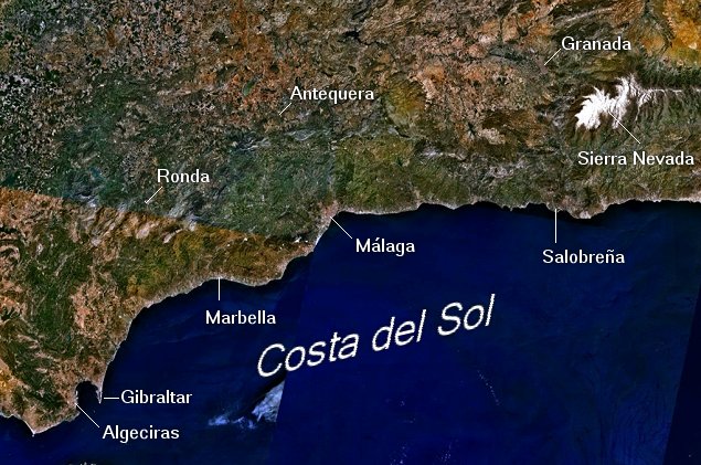
The Costa del Sol is the coastal region of Andalusia around Málaga, stretching from Gibraltar in the west to Motril in the east. Traditionally composed of fishing villages, the area was discovered for international tourism in the 1950s and has since been a popular destination for foreign tourists not only for its beaches, but also its tourist culture. Settlement in the region dates back to the Bronze Age, and it has been alternatively ruled by many cultures such as the Phoenicians, Carthaginians, Romans, Vandals, Visigoths and Moors, before the Reconquista.

The area is heavily urbanised, with a thick ribbon of densely-packed buildings running along most of the coast. Architectural styles are a mixture of low-rise, whitewashed villas and much high-rise development, especially among the tourist resorts, much of it unsympathetic to the geography. The hinterland of Costa del Sol, however, is still in an original state showing much charme.

If you are planning to visit Andalusia you may be interested in having a quick look at several photos of the area. Click on the links at the right to view the pictures. We have taken any attempt to provide exact (GPS-based) coordinates of the positions where the photos have been taken.
Here you see the area of Andalusia from space. Image courtesy of Earth
Sciences and Image Analysis Laboratory, NASA Johnson Space Center.
Málaga - Harbour of Málaga - Alcazaba of Málaga - Teatro Romano and Alcazaba - Bullfight Arena of Málaga - Plaza de la Merced - Avenida Marqués de Larios - Farcade at the Plaza Obispo - Cathedral of Málaga seen from Gibralfaro - Málaga - the uncompleted Tower of the Cathedral - Málaga - Interior of the Cathedral - Staircase and Door in Nerja - Balcon de Europa - View from Balcon de Europa - Cueva de Nerja - Cueva de Nerja - Cueva de Nerja - Corumbela - Sierra de Almijara - Canillas de Albaida and Sierra de Almijara - Sierra de Almijara seen from Corumbela - At the Beach of El Morche - The Beach of El Morche - La Herradura - La Herradura seen from Cerro Gordo - The Beach of El Capricho - The Beach of Salobreña - Salobreña - Sierra del Chaparral - Sierra del Chaparral - Otívar - Rio Verde near Almuñécar - Almuñécar - Sayalonga - Landscape west of Casabermeja - El Torcal and Villanueva de la Concepción - El Torcal - El Torcal - Villanueva de la Concepción seen from El Torcal - Antequera - Fuente de Piedra - Antequera - Embalse de Gaitanejo - Flamingos at Fuente de Piedra - Oleander - Marina of Marbella - Beach of Marbella - Plaza Naranjos - Street in Historic Center of Marbella - Historic Center of Marbella - Street in Historic Center of Marbella - Beach south of Fuengirola - Town Hall of Mijas - Fuengirola seen from Mijas - Church of Cómpeta - Cómpeta - Center of Cómpeta - Landscape south of Cómpeta - Cathedral of Granada - Cathedral of Granada - Organ of the Cathedral of Granada - Alhambra seen from San Cristóbal - Alhambra de Granada - Patio de los Arrayanes - Alhambra de Granada - Patio de los Leones - Alhambra de Granada - Patio de los Arrayanes - Granada - Ceiling of one Room in the Alhambra - Granada - Details of the Interior of the Alhambra - Cathedral of Granada seen from San Cristóbal - Embalse de Canales - Pico Veleta - Sierra Nevada above Pradollano - Güéjar Sierra - Gorge near Lanjarón - Lanjarón - Orgiva and the valley of Rio Guadalfeo - Valley of Rio Guadalfeo - Wind Wheels - Frigiliana - Beach of Almayate - Pass over Sierra de Almijara - Gorge of Rio Alhama - Gibraltar seen from La Linea - Playa de Getares and Gibraltar - Gibraltar seen from Punta del Canero - Africa seen from Punta del Canero - Beach East of Lagos - Frigiliana - Rincón de la Victoria seen from Air - Columned Hall in the Mesquita Cathedral of Córdoba - Vaults in the Mesquita Cathedral of Córdoba