| Earth from Space is a free eBook describing our planet from a satellite's perspective. Fore more information, please read the About pages. |

|

Home  Africa Africa  Namibia Namibia  Kuiseb River Kuiseb River |
|
| See also: Tsauchab River and Sossus Vlei Lakebed | |


|
|
Kuiseb RiverPosition of center of photo (Lat/Long): [-23.116/14.533] |
|
  The Namib Desert stretches along the west coast of Africa, from the Kunene (or Cunene) River in the north to the Orange River in the south. About midway between, a third river, the Kuiseb River (Namibia), stretches toward the Atlantic Ocean. Yet the Kuiseb is impermanent, and years have passed without this river actually reaching the ocean. In 2011, sufficient rainfall propelled the Kuiseb toward the Atlantic Coast for the first time in decades.
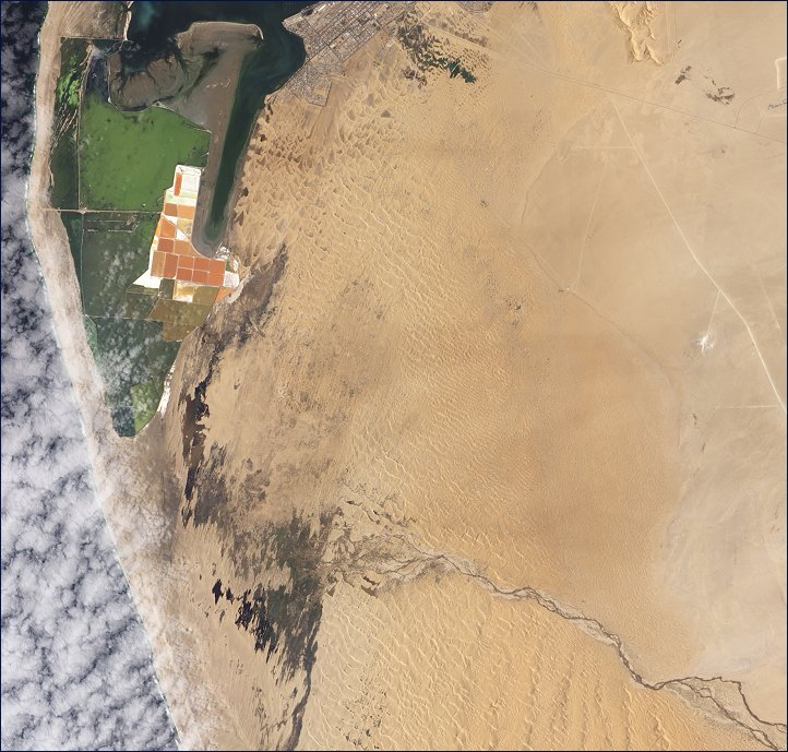
Around Walvis Bay, where the Kuiseb has traditionally drained into the sea, salt works appear as rectangular shapes of orange and brown. Nearby shallow water appears green. South of the salt works, nature takes over. Irregularly shaped dark patches indicate standing water on the desert surface where water has apparently pooled at the end of the Kuiseb River. In the east, the riverís braided channels resemble dark, tangled threads. This image shows numerous sand dunes that have migrated past the Kuiseb and now border on Walvis Bay. By washing out accumulated sand, flash floods on the river generally prevent dunes from migrating past it - when flash floods occur. The cold Benguela Current flowing along the Atlantic Coast prevents much precipitation from moving inland, leaving the Namib Desert parched. Persistently dry conditions allow dunes to continue northward when there is no flowing water in their way. Human activity also has affected the riverís path. A flood in 1963 caused major damage to Walvis Bay, and the subsequent construction of an embankment has blocked the Kuiseb River channel and caused the river to lose direction. Later floods pushed the river into an area of impermanent wetlands, but conditions were too dry to enable the Kuiseb to reach all the way to the Atlantic Ocean until 2011. The pool of water nearest the coast snakes northward to the bay, almost touching the salt works. |
| Source of material: NASA |
Further information: WikiPedia article on Kuiseb River
Last Update: 2011-03-30

