| Earth from Space is a free eBook describing our planet from a satellite's perspective. Fore more information, please read the About pages. |

|
Home  Africa Namibia Etosha Pan and Ekuma River Africa Namibia Etosha Pan and Ekuma River |
|
| See also: Makgadikgadi Salt Pans | |


|
  |
Etosha Pan and Ekuma RiverPosition of center of photo (Lat/Long): [-18.67144/16.09562] |
|

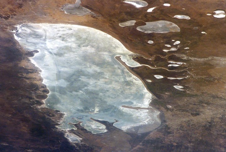
 Etosha Pan in northern Namibia is a large, dry lakebed in the Kalahari Desert. The 120-kilometer-long (75-mile-long) lake and its surroundings are protected as one of Namibias largest wildlife parks. Herds of elephants occupy the dense mopane woodland on the south side of the lake. Mopane trees are common throughout south-central Africa, and host the mopane worm, which is the larval form of the Mopane Emperor Moth and an important source of protein for rural communities. About 16,000 years ago, when ice sheets were melting across Northern Hemisphere land masses, a wet climate phase in southern Africa filled Etosha Lake. Today, Etosha Pan is seldom seen with even a thin sheet of water covering the salt pan. Etosha Pan in northern Namibia is a large, dry lakebed in the Kalahari Desert. The 120-kilometer-long (75-mile-long) lake and its surroundings are protected as one of Namibias largest wildlife parks. Herds of elephants occupy the dense mopane woodland on the south side of the lake. Mopane trees are common throughout south-central Africa, and host the mopane worm, which is the larval form of the Mopane Emperor Moth and an important source of protein for rural communities. About 16,000 years ago, when ice sheets were melting across Northern Hemisphere land masses, a wet climate phase in southern Africa filled Etosha Lake. Today, Etosha Pan is seldom seen with even a thin sheet of water covering the salt pan.
Two images taken about nine months apart document an unusually wet summer in southern Africa. The upper view (March 2006) shows the point where the Ekuma River flows into the salt lake; the lower regional image (June 2005) shows the same inlet - but dry - on the north shore of Etosha Pan. The Ekuma River is almost never seen with water, but in early 2006, rainfall twice the average amount in the rivers catchment generated flow. Greens and browns show vegetation and algae growing in different depths of water where the river enters the dry lake (upper image, center). Typically, little river water or sediment reaches the dry lake because water seeps into the riverbed along its 250-kilometer (55-mile) course, reducing discharge along the way. In this image, there was enough surface flow to reach the Etosha Pan, but too little water reached the mouth of the river to flow beyond the inlet bay. The unusual levels of precipitation also filled several small, usually dry lakes to the north (upper image, right). |
| Source of material: NASA |
Further information: WikiPedia article on Etosha Pan and Ekuma River
Last Update: 2011-03-30