| Earth from Space is a free eBook describing our planet from a satellite's perspective. Fore more information, please read the About pages. |

|

Home  Middle East Middle East  Syria Syria  Syria under Snow Syria under Snow |
|
| See also: Pakistan and Afghanistan in Winter | |


|
|
Syria under SnowPosition of center of photo (Lat/Long): [35.3/38.3] |
|
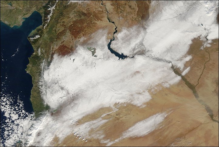
  Snow covered much of Syria on New Year’s Day 2009. In this image, a white swath of snow sweeps through the nation, from the Jabal an Nusayriyah mountains in the west to the border with Turkey in the northeast. Snow covered much of Syria on New Year’s Day 2009. In this image, a white swath of snow sweeps through the nation, from the Jabal an Nusayriyah mountains in the west to the border with Turkey in the northeast.
Syria experiences a range of climates. The coastal plain west of the Jabal an Nusayriyah is humid, receiving regular moisture-rich ocean winds. East of the mountains, the central region of Syria consists of semiarid grasslands. In the east, desert conditions predominate. Along the coast, winters are typically mild and moist. Farther inland, colder wintertime temperatures predominate, and precipitation sometimes falls as snow. The snow cover in this image is broken by river valleys, lakebeds, croplands, and urban areas. The most conspicuous break in the snow cover is Buhayrat al Asad, a reservoir created by a dam on the Euphrates River. East of the reservoir, white snow cover gives way to a triangular-shaped area of gray. This area, near the river valley, consists of a patchwork or cropland. Irrigated fields also line the Euphrates River toward the southeast. |
| Source of material: NASA |
Further information: WikiPedia article on Syria under Snow
Last Update: 2011-03-30

