| Earth from Space is a free eBook describing our planet from a satellite's perspective. Fore more information, please read the About pages. |

|

Home  Australia and Oceania Australia and Oceania  French Polynesia French Polynesia  Iles Gambier Iles Gambier |
|
| See also: Groupe Acteon, Pitcairn Island | |


|
|
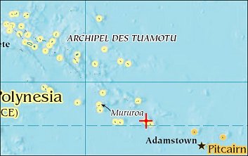
Iles GambierPosition of center of photo (Lat/Long): [-23.16268/-134.95306] |
|
  Iles Gambier is seemingly an anomaly in the Tuamotu Archipelago (French Polynesia), in which 95% of the islands are atolls. This extraordinary island-barrier reef complex is in the southeasternmost end of the Tuamotus, some 120 kilometers from the mature Groupe Acteon. Clearly on a subsiding platform, the reef and lagoon indicate such rapid sinking that shallow lagoonal beaches and lagoonal coral knolls are precluded, except in the very northwest corner. This barrier reef system is in sharp contrast to that of Bora-Bora, where broad coral beaches and a gleaming white shoal lagoon have expanded on a gradually subsiding island mass. The platform on which Iles Gambier sits is undergoing complex subsidence apparent from the topography of the island-reef complex. The reef exposed on the northeast has subsided to depths greater than 75 meters compared to the southwest of the main island. This differential rate is probably created by a submarine fault. Iles Gambier is seemingly an anomaly in the Tuamotu Archipelago (French Polynesia), in which 95% of the islands are atolls. This extraordinary island-barrier reef complex is in the southeasternmost end of the Tuamotus, some 120 kilometers from the mature Groupe Acteon. Clearly on a subsiding platform, the reef and lagoon indicate such rapid sinking that shallow lagoonal beaches and lagoonal coral knolls are precluded, except in the very northwest corner. This barrier reef system is in sharp contrast to that of Bora-Bora, where broad coral beaches and a gleaming white shoal lagoon have expanded on a gradually subsiding island mass. The platform on which Iles Gambier sits is undergoing complex subsidence apparent from the topography of the island-reef complex. The reef exposed on the northeast has subsided to depths greater than 75 meters compared to the southwest of the main island. This differential rate is probably created by a submarine fault.
|
| Source of material: NASA |
Further information: WikiPedia article on Iles Gambier
Last Update: 2011-03-30

